ורדון
קפיצה לניווט
קפיצה לחיפוש
 | |
| מדינה | |
| מחוז | הדרום |
| מועצה אזורית | יואב |
| גובה ממוצע[1] | 100 מטר |
| תאריך ייסוד | 1968 |
| סוג יישוב | יישוב כפרי אחר |
| נתוני אוכלוסייה לפי הלמ"ס לסוף 2023[1] | |
| - אוכלוסייה | 269 תושבים |
| - מתוכם, תושבי ישראל | 269 תושבי ישראל |
<mapframe align="center" height="400" latitude="31.685" longitude="34.795" text="<div style="text-align:center;">מפת היישובים של מועצה אזורית יואב<br />באדום - ורדון<br />בירוק - מיקום בניין המועצה</div>" width="400" zoom="11">[{"properties":{"title":"geomask1","marker-color":"#0000FF"},"type":"ExternalData","service":"geomask","ids":"Q690444"},{"features":[{"type":"Feature","geometry":{"coordinates":[34.8159528349222,31.7738491582361],"type":"Point"},"properties":{"title":"רבדים","marker-color":"#0000FF"}},{"type":"Feature","geometry":{"coordinates":[34.786412,31.758651],"type":"Point"},"properties":{"title":"בניין מועצה אזורית יואב","marker-color":"#00FF00"}},{"type":"Feature","geometry":{"coordinates":[34.7927473831805,31.7456388911405],"type":"Point"},"properties":{"title":"כפר הרי\"ף","marker-color":"#0000FF"}},{"type":"Feature","geometry":{"coordinates":[34.8330195544947,31.7298002649087],"type":"Point"},"properties":{"title":"כפר מנחם","marker-color":"#0000FF"}},{"type":"Feature","geometry":{"coordinates":[34.7979177828812,31.7216665978133],"type":"Point"},"properties":{"title":"אל עזי","marker-color":"#0000FF"}},{"type":"Feature","geometry":{"coordinates":[34.7750125926033,31.7009392190113],"type":"Point"},"properties":{"title":"קדמה","marker-color":"#0000FF"}},{"type":"Feature","geometry":{"coordinates":[34.7803223620595,31.6699335498351],"type":"Point"},"properties":{"title":"סגולה","marker-color":"#0000FF"}},{"type":"Feature","geometry":{"coordinates":[34.7820372846681,31.6638066834433],"type":"Point"},"properties":{"title":"ורדון","marker-color":"#FF0000"}},{"type":"Feature","geometry":{"coordinates":[34.6825125168936,31.6615439879903],"type":"Point"},"properties":{"title":"נגבה","marker-color":"#0000FF"}},{"type":"Feature","geometry":{"coordinates":[34.7949260173389,31.6581671127627],"type":"Point"},"properties":{"title":"נחלה","marker-color":"#0000FF"}},{"type":"Feature","geometry":{"coordinates":[34.8733025443178,31.6476628450553],"type":"Point"},"properties":{"title":"בית ניר","marker-color":"#0000FF"}},{"type":"Feature","geometry":{"coordinates":[34.6772279171296,31.6451086823025],"type":"Point"},"properties":{"title":"שדה יואב","marker-color":"#0000FF"}},{"type":"Feature","geometry":{"coordinates":[34.8478423554587,31.6338859568682],"type":"Point"},"properties":{"title":"גלאון","marker-color":"#0000FF"}},{"type":"Feature","geometry":{"coordinates":[34.7947430302921,31.6277741224185],"type":"Point"},"properties":{"title":"גת (קיבוץ)","marker-color":"#0000FF"}},{"type":"Feature","geometry":{"coordinates":[34.8959775996161,31.6130883997066],"type":"Point"},"properties":{"title":"בית גוברין","marker-color":"#0000FF"}}],"type":"FeatureCollection"}]</mapframe>
| |
| מדד חברתי-כלכלי - אשכול לשנת 2021[2] |
7 מתוך 10 |
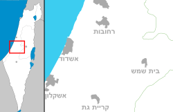
וַרְדּוֹן הוא יישוב קהילתי בשפלה הדרומית. הוא שוכן צפונית לקריית גת ודרומית לקריית מלאכי ובו מתגוררים כ-300 תושבים. היישוב שייך למועצה אזורית יואב.
ורדון הוקם בשנת 1964 כמרכז כפרי, והפך ליישוב קהילתי בשנת 1998. היישוב נמצא במרכזו של צומת דרכים בין שלושה מושבים גדולים: מנוחה, נחלה וסגולה.
שמו של היישוב הוא מעין תרגום של שם משפחתו של ג'וליוס רוזנוולד, נדבן יהודי מארצות הברית.
חינוך
תלמידי היישוב לומדים במוסדות החינוך של המועצה האזורית יואב.
תלמידי בית ספר יסודי לומדים בבית הספר "נוף השדות" שבקיבוץ נגבה.
תלמידי התיכון לומדים ב"צפית" בקיבוץ כפר מנחם.
קישורים חיצוניים
- ורדון, באתר מועצה אזורית יואב
הערות שוליים
- ^ 1 2 אוכלוסייה בעיריות, במועצות המקומיות והאזוריות וביישובים בעלי 2,000 תושבים לפחות - לפי טבלה חודשית של למ"ס עבור סוף דצמבר 2024 (אומדן), בכל יתר היישובים - לפי טבלה שנתית של למ"ס עבור סוף 2023.
- ^ הנתונים לפי טבלת מדד חברתי כלכלי של למ"ס נכון לשנת 2021
| ||||||||||||||||


