שומרה (מושב)
קפיצה לניווט
קפיצה לחיפוש
 מראה כללי של שומרה מגבעת איקרית מראה כללי של שומרה מגבעת איקרית
| |
| מדינה | |
| מחוז | הצפון |
| מועצה אזורית | מעלה יוסף |
| גובה ממוצע[1] | 548 מטר |
| תאריך ייסוד | 1949 |
| תנועה מיישבת | תנועת המושבים |
| סוג יישוב | מושב |
| נתוני אוכלוסייה לפי הלמ"ס לסוף 2023[1] | |
| - אוכלוסייה | 412 תושבים |
| - מתוכם, תושבי ישראל | 388 תושבי ישראל |
(למפת הגליל המערבי רגילה)  שומרה
<mapframe align="center" height="350" latitude="33.02957279478" longitude="35.268994926439" text="<div style="text-align:center;">מפת היישובים של מועצה אזורית מעלה יוסף<br />באדום - שומרה<br />בירוק - מיקום בניין המועצה</div>" width="350" zoom="11">[{"properties":{"title":"geomask1","marker-color":"#0000FF"},"type":"ExternalData","service":"geomask","ids":"Q2436968"},{"features":[{"type":"Feature","geometry":{"coordinates":[35.2884285901586,33.1000753391237],"type":"Point"},"properties":{"title":"כפר רוזנואלד (זרעית)","marker-color":"#0000FF"}},{"type":"Feature","geometry":{"coordinates":[35.3142274118729,33.0852681505385],"type":"Point"},"properties":{"title":"שתולה","marker-color":"#0000FF"}},{"type":"Feature","geometry":{"coordinates":[35.2836999606391,33.0832175027644],"type":"Point"},"properties":{"title":"שומרה","marker-color":"#FF0000"}},{"type":"Feature","geometry":{"coordinates":[35.2940800866093,33.0742840735125],"type":"Point"},"properties":{"title":"אבן מנחם","marker-color":"#0000FF"}},{"type":"Feature","geometry":{"coordinates":[35.1865589462461,33.0674623913372],"type":"Point"},"properties":{"title":"יערה","marker-color":"#0000FF"}},{"type":"Feature","geometry":{"coordinates":[35.3235180635447,33.0647018546551],"type":"Point"},"properties":{"title":"נטועה","marker-color":"#0000FF"}},{"type":"Feature","geometry":{"coordinates":[35.247027,33.061827],"type":"Point"},"properties":{"title":"בניין מועצה אזורית מעלה יוסף","marker-color":"#00FF00"}},{"type":"Feature","geometry":{"coordinates":[35.2492004113542,33.0599719041368],"type":"Point"},"properties":{"title":"גורנות הגליל","marker-color":"#0000FF"}},{"type":"Feature","geometry":{"coordinates":[35.2363499935507,33.0566397118891],"type":"Point"},"properties":{"title":"גורן","marker-color":"#0000FF"}},{"type":"Feature","geometry":{"coordinates":[35.180460347876,33.0479855175853],"type":"Point"},"properties":{"title":"עבדון","marker-color":"#0000FF"}},{"type":"Feature","geometry":{"coordinates":[35.3575295050011,33.0411314123806],"type":"Point"},"properties":{"title":"מתת","marker-color":"#0000FF"}},{"type":"Feature","geometry":{"coordinates":[35.1947006565775,33.038790505701],"type":"Point"},"properties":{"title":"מנות","marker-color":"#0000FF"}},{"type":"Feature","geometry":{"coordinates":[35.2868714519019,33.0384931746318],"type":"Point"},"properties":{"title":"אבירים","marker-color":"#0000FF"}},{"type":"Feature","geometry":{"coordinates":[35.2442643056929,33.0364402301933],"type":"Point"},"properties":{"title":"מצפה הילה","marker-color":"#0000FF"}},{"type":"Feature","geometry":{"coordinates":[35.3237970029429,33.0333238205845],"type":"Point"},"properties":{"title":"אלקוש","marker-color":"#0000FF"}},{"type":"Feature","geometry":{"coordinates":[35.1837842008214,33.0269773806664],"type":"Point"},"properties":{"title":"נווה זיו","marker-color":"#0000FF"}},{"type":"Feature","geometry":{"coordinates":[35.2609509706916,33.0162365182341],"type":"Point"},"properties":{"title":"מעונה","marker-color":"#0000FF"}},{"type":"Feature","geometry":{"coordinates":[35.2294840333785,33.0094842996632],"type":"Point"},"properties":{"title":"עין יעקב","marker-color":"#0000FF"}},{"type":"Feature","geometry":{"coordinates":[35.3138091627418,33.0068240518574],"type":"Point"},"properties":{"title":"צוריאל","marker-color":"#0000FF"}},{"type":"Feature","geometry":{"coordinates":[35.2974268122212,32.9978206692716],"type":"Point"},"properties":{"title":"חוסן","marker-color":"#0000FF"}},{"type":"Feature","geometry":{"coordinates":[35.3229813798794,32.9837329770616],"type":"Point"},"properties":{"title":"פקיעין החדשה","marker-color":"#0000FF"}},{"type":"Feature","geometry":{"coordinates":[35.2489396694538,32.9671004194114],"type":"Point"},"properties":{"title":"גיתה","marker-color":"#0000FF"}},{"type":"Feature","geometry":{"coordinates":[35.2618772012981,32.9590702504367],"type":"Point"},"properties":{"title":"לפידות","marker-color":"#0000FF"}}],"type":"FeatureCollection"}]</mapframe>
| |
| מדד חברתי-כלכלי - אשכול לשנת 2021[2] |
7 מתוך 10 |


שׁוֹמֵרָה הוא מושב בגליל המערבי ליד גבולה של ישראל עם לבנון השייך למועצה אזורית מעלה יוסף.
בשל מלחמת חרבות ברזל המושב שומרה מפונה מתושביו.
היסטוריה
המושב הוקם בשנת 1949 במקומו של היישוב תרביחא שנעזב במהלך מבצע חירם שבמלחמת העצמאות[3][4][5][6][7][8][9]. המתיישבים הראשונים היו עולים מרומניה והונגריה, אשר נטשו אף הם את היישוב כבר באותה שנה. במהלך 1950 הגיעו למקום עולים ממרוקו. באוקטובר 1955 פרצה דליקה גדולה במושב שכילתה הרבה שטחי מטעים וכן מספר בתי מגורים במושב[10].
שמו של המושב הוא סמלי, בשל קרבתו לגבול ישראל–לבנון. סביב המצודה שבקצה המושב, ממוקמת מפקדת עוצבת ברעם.
באוקטובר 2023 במהלך מלחמת חרבות ברזל בעקבות איומים על היישוב ונפילות טילים פונה מושב שומרה מתושביו[11].
גלריה
-
 מצודת טגארט בשומרה
 -
 רחוב במושב
 -
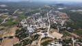 שומרה ממבט של ציפור


קישורים חיצוניים
- שומרה (אורכב 04.03.2016 בארכיון Wayback Machine) במרכז המידע להתיישבות בגליל
- שומרה באתר הרשות לפיתוח הגליל
הערות שוליים
- ^ 1 2 אוכלוסייה בעיריות, במועצות המקומיות והאזוריות וביישובים בעלי 2,000 תושבים לפחות - לפי טבלה חודשית של למ"ס עבור סוף דצמבר 2024 (אומדן), בכל יתר היישובים - לפי טבלה שנתית של למ"ס עבור סוף 2023.
- ^ הנתונים לפי טבלת מדד חברתי כלכלי של למ"ס נכון לשנת 2021
- ^ עמנואל הראובני, לקסיקון ארץ ישראל, משרד החינוך, מטח, 2010, עמ' 910
- ^ עורך: זאב ענר, כל מקום ואתר: מדריך לכל מקום ואתר בארץ ישראל, משרד הביטחון – ההוצאה לאור, 2000, עמ' 304
- ^ Benny Morris, The Birth of the Palestinian Refugee Problem Revisited, Cambridge University Press, 2004, p. xx
- ^ שומרה באתר תנועת העבודה הישראלית
- ^ שומרה באתר מועצה אזורית מעלה יוסף
- ^ שומרה באתר תנועת אור
- ^ יהרסו הבתים הישנים בכפר שומרה, הארץ, 5 ביוני 1959
- ^ דליקה גדולה בכפר שמרה, דבר, 23 באוקטובר 1955
- ^ משרד הביטחון מפנה 28 ישובים בצפון לבתי הארחה בסבסוד המדינה, באתר www.inn.co.il
| ||||||||||