דבורה (מושב)
קפיצה לניווט
קפיצה לחיפוש
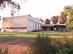
 בית העם במושב דבורה בית העם במושב דבורה
| |
| מדינה | |
| מחוז | הצפון |
| מועצה אזורית | הגלבוע |
| גובה ממוצע[1] | 69 מטר |
| תאריך ייסוד | 1956 |
| תנועה מיישבת | תנועת המושבים |
| סוג יישוב | מושב |
| נתוני אוכלוסייה לפי הלמ"ס לסוף 2023[1] | |
| - אוכלוסייה | 338 תושבים |
| - מתוכם, תושבי ישראל | 325 תושבי ישראל |
<mapframe align="left" height="350" latitude="32.574366413977" longitude="35.37" text="<center>מפת היישובים של מועצה אזורית הגלבוע<br />באדום - דבורה<br />בירוק - מיקום בניין המועצה</center>" width="440" zoom="11">[{"properties":{"title":"geomask1","fill-opacity":0.5},"type":"ExternalData","service":"geomask","ids":"Q2915451"},{"features":[{"type":"Feature","geometry":{"coordinates":[35.4038295523919,32.634494352941],"type":"Point"},"properties":{"fill-opacity":0.5,"title":"טמרה (יזרעאל)","marker-color":"#0000FF"}},{"type":"Feature","geometry":{"coordinates":[35.3913189370767,32.6141347433161],"type":"Point"},"properties":{"fill-opacity":0.5,"title":"נאעורה","marker-color":"#0000FF"}},{"type":"Feature","geometry":{"coordinates":[35.4448829237101,32.6040344228854],"type":"Point"},"properties":{"fill-opacity":0.5,"title":"טייבה (בעמק)","marker-color":"#0000FF"}},{"type":"Feature","geometry":{"coordinates":[35.4144917288495,32.5911943329735],"type":"Point"},"properties":{"fill-opacity":0.5,"title":"רמת צבי","marker-color":"#0000FF"}},{"type":"Feature","geometry":{"coordinates":[35.4406818868611,32.5863686310873],"type":"Point"},"properties":{"fill-opacity":0.5,"title":"מולדת","marker-color":"#0000FF"}},{"type":"Feature","geometry":{"coordinates":[35.2452282647887,32.5690907416102],"type":"Point"},"properties":{"fill-opacity":0.5,"title":"ניר יפה","marker-color":"#0000FF"}},{"type":"Feature","geometry":{"coordinates":[35.3598078526278,32.5671978179608],"type":"Point"},"properties":{"fill-opacity":0.5,"title":"כפר יחזקאל","marker-color":"#0000FF"}},{"type":"Feature","geometry":{"coordinates":[35.3720521862433,32.5662803427296],"type":"Point"},"properties":{"fill-opacity":0.5,"title":"גבע","marker-color":"#0000FF"}},{"type":"Feature","geometry":{"coordinates":[35.2373461228539,32.5638630146604],"type":"Point"},"properties":{"fill-opacity":0.5,"title":"מלאה","marker-color":"#0000FF"}},{"type":"Feature","geometry":{"coordinates":[35.3912142255067,32.5636382899436],"type":"Point"},"properties":{"fill-opacity":0.5,"title":"עין חרוד איחוד","marker-color":"#0000FF"}},{"type":"Feature","geometry":{"coordinates":[35.2424571037704,32.5633205354398],"type":"Point"},"properties":{"fill-opacity":0.5,"title":"מרכז אומן","marker-color":"#0000FF"}},{"type":"Feature","geometry":{"coordinates":[35.3210399852088,32.5621901087044],"type":"Point"},"properties":{"fill-opacity":0.5,"title":"יזרעאל","marker-color":"#0000FF"}},{"type":"Feature","geometry":{"coordinates":[35.2447977526787,32.5589013237482],"type":"Point"},"properties":{"fill-opacity":0.5,"title":"גדיש","marker-color":"#0000FF"}},{"type":"Feature","geometry":{"coordinates":[35.3915228249051,32.5584078014186],"type":"Point"},"properties":{"fill-opacity":0.5,"title":"עין חרוד מאוחד","marker-color":"#0000FF"}},{"type":"Feature","geometry":{"coordinates":[35.3074052246211,32.5576933714971],"type":"Point"},"properties":{"fill-opacity":0.5,"title":"אביטל","marker-color":"#0000FF"}},{"type":"Feature","geometry":{"coordinates":[35.399610355648,32.5562313419114],"type":"Point"},"properties":{"fill-opacity":0.5,"title":"תל יוסף","marker-color":"#0000FF"}},{"type":"Feature","geometry":{"coordinates":[35.2640662135822,32.5528520594282],"type":"Point"},"properties":{"fill-opacity":0.5,"title":"דבורה","marker-color":"#FF0000"}},{"type":"Feature","geometry":{"coordinates":[35.3080374558642,32.5519217702802],"type":"Point"},"properties":{"fill-opacity":0.5,"title":"מרכז יעל","marker-color":"#0000FF"}},{"type":"Feature","geometry":{"coordinates":[35.4387805077462,32.5514753658626],"type":"Point"},"properties":{"fill-opacity":0.5,"title":"בית השיטה","marker-color":"#0000FF"}},{"type":"Feature","geometry":{"coordinates":[35.394968,32.550219],"type":"Point"},"properties":{"fill-opacity":0.5,"title":"בניין מועצה אזורית הגלבוע","marker-color":"#00FF00"}},{"type":"Feature","geometry":{"coordinates":[35.3586053632972,32.5489843491178],"type":"Point"},"properties":{"fill-opacity":0.5,"title":"גדעונה","marker-color":"#0000FF"}},{"type":"Feature","geometry":{"coordinates":[35.2719421290988,32.5489706272988],"type":"Point"},"properties":{"fill-opacity":0.5,"title":"אדירים","marker-color":"#0000FF"}},{"type":"Feature","geometry":{"coordinates":[35.2643823928825,32.5479825534264],"type":"Point"},"properties":{"fill-opacity":0.5,"title":"מרכז חבר","marker-color":"#0000FF"}},{"type":"Feature","geometry":{"coordinates":[35.3007910964203,32.5458859291354],"type":"Point"},"properties":{"fill-opacity":0.5,"title":"מיטב","marker-color":"#0000FF"}},{"type":"Feature","geometry":{"coordinates":[35.3107984310534,32.5457876836878],"type":"Point"},"properties":{"fill-opacity":0.5,"title":"פרזון","marker-color":"#0000FF"}},{"type":"Feature","geometry":{"coordinates":[35.264911275338,32.5428424206693],"type":"Point"},"properties":{"fill-opacity":0.5,"title":"ברק","marker-color":"#0000FF"}},{"type":"Feature","geometry":{"coordinates":[35.3597623627418,32.5407771615309],"type":"Point"},"properties":{"fill-opacity":0.5,"title":"נורית","marker-color":"#0000FF"}},{"type":"Feature","geometry":{"coordinates":[35.3379258269829,32.5319652701614],"type":"Point"},"properties":{"fill-opacity":0.5,"title":"גן נר","marker-color":"#0000FF"}},{"type":"Feature","geometry":{"coordinates":[35.2596850431375,32.5268841198289],"type":"Point"},"properties":{"fill-opacity":0.5,"title":"רם און","marker-color":"#0000FF"}},{"type":"Feature","geometry":{"coordinates":[35.3233305500352,32.5226920537717],"type":"Point"},"properties":{"fill-opacity":0.5,"title":"סנדלה","marker-color":"#0000FF"}},{"type":"Feature","geometry":{"coordinates":[35.3076827858786,32.5210827556756],"type":"Point"},"properties":{"fill-opacity":0.5,"title":"מגן שאול","marker-color":"#0000FF"}},{"type":"Feature","geometry":{"coordinates":[35.4257107174255,32.5185858528049],"type":"Point"},"properties":{"fill-opacity":0.5,"title":"חפציבה","marker-color":"#0000FF"}},{"type":"Feature","geometry":{"coordinates":[35.4314542733503,32.5171328324454],"type":"Point"},"properties":{"fill-opacity":0.5,"title":"בית אלפא","marker-color":"#0000FF"}},{"type":"Feature","geometry":{"coordinates":[35.2961810756462,32.5142384750122],"type":"Point"},"properties":{"fill-opacity":0.5,"title":"מוקייבלה","marker-color":"#0000FF"}}],"type":"FeatureCollection"}]</mapframe>
| |
| מדד חברתי-כלכלי - אשכול לשנת 2021[2] |
8 מתוך 10 |

דְּבוֹרָה הוא מושב באזור הצפון שנמצא בגוש חבר חלק משלושת גושי היישובים שבחבל יישובי תענך שבאזור עפולה, בדרום מזרח עמק יזרעאל, ומצפון לקו הירוק, ושייך למועצה האזורית הגלבוע.
היסטוריה
היישוב הוקם בשנת 1956 על ידי עולים מגרעין "שובה" מרקש שבמרוקו כחלק ממבצע אכלוס חבל תענך שבעמק יזרעאל.[3]
שמו של היישוב הוא על שם דבורה הנביאה שכפי הנראה ניצחה את סיסרא במקום המושב כיום.

ביישוב גני ילדים, בריכה, בית כנסת ובית ספר יסודי "יד לחמישה".
בשנת 1994 הוקם ביישוב מפעל פריניב - מפעל לייצור מיצים.
קישורים חיצוניים
- דבורה באתר הרשות לפיתוח הגליל
- דבורה, במרכז המידע לנגב ולגליל של תנועת אור
הערות שוליים
- ^ 1 2 אוכלוסייה בעיריות, במועצות המקומיות והאזוריות וביישובים בעלי 2,000 תושבים לפחות - לפי טבלה חודשית של למ"ס עבור סוף דצמבר 2024 (אומדן), בכל יתר היישובים - לפי טבלה שנתית של למ"ס עבור סוף 2023.
- ^ הנתונים לפי טבלת מדד חברתי כלכלי של למ"ס נכון לשנת 2021
- ^ יהודה גרינקר, עלית יהודי האטלס, תל אביב תשל"ג, עמ' 57 - 58.
| ||||||||||||||


