מחסיה
קפיצה לניווט
קפיצה לחיפוש
 שלט הכניסה למושב שלט הכניסה למושב
| |
| מדינה | |
| מחוז | ירושלים |
| מועצה אזורית | מטה יהודה |
| גובה ממוצע[1] | 251 מטר |
| תאריך ייסוד | 1950 |
| תנועה מיישבת | הפועל המזרחי |
| סוג יישוב | מושב |
| נתוני אוכלוסייה לפי הלמ"ס לסוף 2023[1] | |
| - אוכלוסייה | 500 תושבים |
| - מתוכם, תושבי ישראל | 497 תושבי ישראל |
<mapframe align="center" height="480" latitude="31.73" longitude="35.05" text="<div style="text-align:center;">מפת היישובים של מועצה אזורית מטה יהודה<br />באדום - מחסיה<br />בירוק - מיקום בניין המועצה</div>" width="560" zoom="11">[{"properties":{"title":"geomask1","marker-color":"#0000FF"},"type":"ExternalData","service":"geomask","ids":"Q799284"},{"features":[{"type":"Feature","geometry":{"coordinates":[35.0676465923132,31.831996523923],"type":"Point"},"properties":{"marker-size":"small","title":"נטף","marker-color":"#0000FF"}},{"type":"Feature","geometry":{"coordinates":[34.9556763879237,31.8311952910857],"type":"Point"},"properties":{"marker-size":"small","title":"נחשון","marker-color":"#0000FF"}},{"type":"Feature","geometry":{"coordinates":[34.925683807344,31.8287882530478],"type":"Point"},"properties":{"marker-size":"small","title":"בקוע","marker-color":"#0000FF"}},{"type":"Feature","geometry":{"coordinates":[34.9785260223232,31.8177104860201],"type":"Point"},"properties":{"marker-size":"small","title":"נווה שלום","marker-color":"#0000FF"}},{"type":"Feature","geometry":{"coordinates":[35.1108655293526,31.8176965390773],"type":"Point"},"properties":{"marker-size":"small","title":"מעלה החמישה","marker-color":"#0000FF"}},{"type":"Feature","geometry":{"coordinates":[35.1055892371023,31.8133637233424],"type":"Point"},"properties":{"marker-size":"small","title":"ידידה","marker-color":"#0000FF"}},{"type":"Feature","geometry":{"coordinates":[35.1042181172241,31.8116491574271],"type":"Point"},"properties":{"marker-size":"small","title":"כפר הנוער קריית יערים","marker-color":"#0000FF"}},{"type":"Feature","geometry":{"coordinates":[35.1197440454182,31.8104880714421],"type":"Point"},"properties":{"marker-size":"small","title":"קריית ענבים","marker-color":"#0000FF"}},{"type":"Feature","geometry":{"coordinates":[35.0896460020013,31.8098331480275],"type":"Point"},"properties":{"marker-size":"small","title":"יד השמונה","marker-color":"#0000FF"}},{"type":"Feature","geometry":{"coordinates":[34.9495047953107,31.8090881446983],"type":"Point"},"properties":{"marker-size":"small","title":"הראל","marker-color":"#0000FF"}},{"type":"Feature","geometry":{"coordinates":[35.081305276587,31.8080216612364],"type":"Point"},"properties":{"marker-size":"small","title":"נווה אילן","marker-color":"#0000FF"}},{"type":"Feature","geometry":{"coordinates":[34.9026278172536,31.8051075720472],"type":"Point"},"properties":{"marker-size":"small","title":"טל שחר","marker-color":"#0000FF"}},{"type":"Feature","geometry":{"coordinates":[34.9389559238356,31.8049181045212],"type":"Point"},"properties":{"marker-size":"small","title":"גיזו","marker-color":"#0000FF"}},{"type":"Feature","geometry":{"coordinates":[34.9312479980794,31.8045410346457],"type":"Point"},"properties":{"marker-size":"small","title":"צלפון","marker-color":"#0000FF"}},{"type":"Feature","geometry":{"coordinates":[35.1259800699809,31.8045399435034],"type":"Point"},"properties":{"marker-size":"small","title":"בית נקופה","marker-color":"#0000FF"}},{"type":"Feature","geometry":{"coordinates":[35.0111939894389,31.8023429777083],"type":"Point"},"properties":{"marker-size":"small","title":"מסילת ציון","marker-color":"#0000FF"}},{"type":"Feature","geometry":{"coordinates":[34.9746594932368,31.8010195980549],"type":"Point"},"properties":{"marker-size":"small","title":"תעוז","marker-color":"#0000FF"}},{"type":"Feature","geometry":{"coordinates":[35.0780447265119,31.7982786031418],"type":"Point"},"properties":{"marker-size":"small","title":"שואבה","marker-color":"#0000FF"}},{"type":"Feature","geometry":{"coordinates":[35.0653748392207,31.7971831610626],"type":"Point"},"properties":{"marker-size":"small","title":"שורש","marker-color":"#0000FF"}},{"type":"Feature","geometry":{"coordinates":[35.0367642537881,31.7940823776834],"type":"Point"},"properties":{"marker-size":"small","title":"בית מאיר","marker-color":"#0000FF"}},{"type":"Feature","geometry":{"coordinates":[35.1576664639112,31.7938236757914],"type":"Point"},"properties":{"marker-size":"small","title":"מוצא עילית","marker-color":"#0000FF"}},{"type":"Feature","geometry":{"coordinates":[34.9465916293051,31.7933001429528],"type":"Point"},"properties":{"marker-size":"small","title":"כפר אוריה","marker-color":"#0000FF"}},{"type":"Feature","geometry":{"coordinates":[35.1198653605666,31.7932630230601],"type":"Point"},"properties":{"marker-size":"small","title":"עין נקובא","marker-color":"#0000FF"}},{"type":"Feature","geometry":{"coordinates":[35.115011071178,31.7902836244628],"type":"Point"},"properties":{"marker-size":"small","title":"עין ראפה","marker-color":"#0000FF"}},{"type":"Feature","geometry":{"coordinates":[35.091997161122,31.7869285307505],"type":"Point"},"properties":{"marker-size":"small","title":"גבעת יערים","marker-color":"#0000FF"}},{"type":"Feature","geometry":{"coordinates":[35.1194519177937,31.7835228628547],"type":"Point"},"properties":{"marker-size":"small","title":"צובה","marker-color":"#0000FF"}},{"type":"Feature","geometry":{"coordinates":[34.9817778473593,31.782995509285],"type":"Point"},"properties":{"marker-size":"small","title":"תרום","marker-color":"#0000FF"}},{"type":"Feature","geometry":{"coordinates":[35.1617899091645,31.7821011884514],"type":"Point"},"properties":{"marker-size":"small","title":"בית זית","marker-color":"#0000FF"}},{"type":"Feature","geometry":{"coordinates":[35.009126569642,31.7811466064154],"type":"Point"},"properties":{"marker-size":"small","title":"אשתאול","marker-color":"#0000FF"}},{"type":"Feature","geometry":{"coordinates":[35.095279567314,31.7789951866804],"type":"Point"},"properties":{"marker-size":"small","title":"בית חולים איתנים","marker-color":"#0000FF"}},{"type":"Feature","geometry":{"coordinates":[35.1530291025659,31.7782200200254],"type":"Point"},"properties":{"marker-size":"small","title":"בית ספר אזורי עין כרם","marker-color":"#0000FF"}},{"type":"Feature","geometry":{"coordinates":[34.9471660414334,31.7765271205505],"type":"Point"},"properties":{"marker-size":"small","title":"דיר ראפאת","marker-color":"#0000FF"}},{"type":"Feature","geometry":{"coordinates":[34.9517099853645,31.7749129230047],"type":"Point"},"properties":{"marker-size":"small","title":"גבעת שמש","marker-color":"#0000FF"}},{"type":"Feature","geometry":{"coordinates":[35.0493630192319,31.7740775125737],"type":"Point"},"properties":{"marker-size":"small","title":"כסלון","marker-color":"#0000FF"}},{"type":"Feature","geometry":{"coordinates":[35.0732218553574,31.7738338269269],"type":"Point"},"properties":{"marker-size":"small","title":"רמת רזיאל","marker-color":"#0000FF"}},{"type":"Feature","geometry":{"coordinates":[35.0034572593471,31.7664377588314],"type":"Point"},"properties":{"marker-size":"small","title":"נחם","marker-color":"#0000FF"}},{"type":"Feature","geometry":{"coordinates":[34.999254,31.764413],"type":"Point"},"properties":{"marker-size":"small","title":"בניין מועצה אזורית מטה יהודה","marker-color":"#00FF00"}},{"type":"Feature","geometry":{"coordinates":[34.9691591871385,31.7629519256861],"type":"Point"},"properties":{"marker-size":"small","title":"צרעה","marker-color":"#0000FF"}},{"type":"Feature","geometry":{"coordinates":[35.134670861365,31.7628799178354],"type":"Point"},"properties":{"marker-size":"small","title":"אבן ספיר","marker-color":"#0000FF"}},{"type":"Feature","geometry":{"coordinates":[35.1529369884034,31.7539603633985],"type":"Point"},"properties":{"marker-size":"small","title":"אורה","marker-color":"#0000FF"}},{"type":"Feature","geometry":{"coordinates":[35.1416451719615,31.7516104839557],"type":"Point"},"properties":{"marker-size":"small","title":"עמינדב","marker-color":"#0000FF"}},{"type":"Feature","geometry":{"coordinates":[34.9655995012156,31.7515820750631],"type":"Point"},"properties":{"marker-size":"small","title":"ישעי","marker-color":"#0000FF"}},{"type":"Feature","geometry":{"coordinates":[34.8860231397608,31.7507764795177],"type":"Point"},"properties":{"marker-size":"small","title":"תירוש","marker-color":"#0000FF"}},{"type":"Feature","geometry":{"coordinates":[35.0072967920365,31.7478657914362],"type":"Point"},"properties":{"marker-size":"small","title":"מחסיה","marker-color":"#FF0000"}},{"type":"Feature","geometry":{"coordinates":[35.0583816793908,31.7452291757573],"type":"Point"},"properties":{"marker-size":"small","title":"נס הרים","marker-color":"#0000FF"}},{"type":"Feature","geometry":{"coordinates":[34.8785648255164,31.7407471563755],"type":"Point"},"properties":{"marker-size":"small","title":"גפן","marker-color":"#0000FF"}},{"type":"Feature","geometry":{"coordinates":[35.2183733116408,31.7398110594845],"type":"Point"},"properties":{"marker-size":"small","title":"רמת רחל","marker-color":"#0000FF"}},{"type":"Feature","geometry":{"coordinates":[34.9992041653401,31.7325216125401],"type":"Point"},"properties":{"marker-size":"small","title":"זנוח","marker-color":"#0000FF"}},{"type":"Feature","geometry":{"coordinates":[35.0724398041795,31.7298229476091],"type":"Point"},"properties":{"marker-size":"small","title":"בר גיורא","marker-color":"#0000FF"}},{"type":"Feature","geometry":{"coordinates":[35.1058976031625,31.721826803964],"type":"Point"},"properties":{"marker-size":"small","title":"מבוא ביתר","marker-color":"#0000FF"}},{"type":"Feature","geometry":{"coordinates":[34.9205199814769,31.721187485243],"type":"Point"},"properties":{"marker-size":"small","title":"שדות מיכה","marker-color":"#0000FF"}},{"type":"Feature","geometry":{"coordinates":[35.0621170868133,31.7179975896608],"type":"Point"},"properties":{"marker-size":"small","title":"מטע","marker-color":"#0000FF"}},{"type":"Feature","geometry":{"coordinates":[34.9449243908007,31.7096959376404],"type":"Point"},"properties":{"marker-size":"small","title":"זכריה","marker-color":"#0000FF"}},{"type":"Feature","geometry":{"coordinates":[34.9122584470188,31.6977207528911],"type":"Point"},"properties":{"marker-size":"small","title":"עגור","marker-color":"#0000FF"}},{"type":"Feature","geometry":{"coordinates":[34.9825322978636,31.6880324423825],"type":"Point"},"properties":{"marker-size":"small","title":"נתיב הל\"ה","marker-color":"#0000FF"}},{"type":"Feature","geometry":{"coordinates":[34.8866650863877,31.6863863375325],"type":"Point"},"properties":{"marker-size":"small","title":"לוזית","marker-color":"#0000FF"}},{"type":"Feature","geometry":{"coordinates":[35.0168229259067,31.6817746073788],"type":"Point"},"properties":{"marker-size":"small","title":"אביעזר","marker-color":"#0000FF"}},{"type":"Feature","geometry":{"coordinates":[34.9349954840145,31.6774792451615],"type":"Point"},"properties":{"marker-size":"small","title":"שריגים (לי-און)","marker-color":"#0000FF"}},{"type":"Feature","geometry":{"coordinates":[35.0054517252359,31.6729191684556],"type":"Point"},"properties":{"marker-size":"small","title":"נווה מיכאל","marker-color":"#0000FF"}},{"type":"Feature","geometry":{"coordinates":[34.9454533662219,31.6711879649143],"type":"Point"},"properties":{"marker-size":"small","title":"גבעת ישעיהו","marker-color":"#0000FF"}},{"type":"Feature","geometry":{"coordinates":[34.9949341264531,31.6605468734791],"type":"Point"},"properties":{"marker-size":"small","title":"אדרת","marker-color":"#0000FF"}},{"type":"Feature","geometry":{"coordinates":[34.9439025715337,31.6600919889999],"type":"Point"},"properties":{"marker-size":"small","title":"צפרירים","marker-color":"#0000FF"}},{"type":"Feature","geometry":{"coordinates":[34.9542101055324,31.6302611523296],"type":"Point"},"properties":{"marker-size":"small","title":"נחושה","marker-color":"#0000FF"}},{"type":"Feature","geometry":{"coordinates":[34.9249340070787,31.6213620945592],"type":"Point"},"properties":{"marker-size":"small","title":"כפר זוהרים","marker-color":"#0000FF"}}],"type":"FeatureCollection"}]</mapframe>
| |
| מדד חברתי-כלכלי - אשכול לשנת 2021[2] |
6 מתוך 10 |
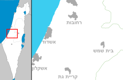
מַחְסֵיָה הוא מושב ליד בית שמש, השייך למועצה אזורית מטה יהודה שבמחוז ירושלים.
היסטוריה
המושב הוקם בשנת 1950 על ידי עולים מתימן, על חלק מאדמות הכפר הנטוש דיר אבאן[3][4][5][6]. המושב ננטש לאחר מספר שנים, ויושב מחדש מאוחר יותר על ידי עולים ממרוקו ומקוצ'ין שבהודו.
המושב חבר בתנועה המיישבת "הפועל המזרחי".
שם המושב לקוח מתוך ספר ירמיהו, שם הוא משמש שם פרטי:
וָאֶתֵּן אֶת-הַסֵּפֶר הַמִּקְנָה, אֶל-בָּרוּךְ בֶּן-נֵרִיָּה בֶּן-מַחְסֵיָה, לְעֵינֵי חֲנַמְאֵל דֹּדִי, וּלְעֵינֵי הָעֵדִים הַכֹּתְבִים בְּסֵפֶר הַמִּקְנָה--לְעֵינֵי, כָּל-הַיְּהוּדִים, הַיֹּשְׁבִים, בַּחֲצַר הַמַּטָּרָה
— ירמיהו, ל"ב, י"ב
גלריית תמונות
קישורים חיצוניים
- ליליה קירשנבאום, מחסיה, חורבת אל- צוייאע', העתקת בית בד, אתר רשות העתיקות – מינהל שימור, אפריל-אוקטובר 2005.
- מידע על מחסיה בקטלוג הספרייה הלאומית
 מחסיה (ישראל), דף שער בספרייה הלאומית
הערות שוליים
- ^ 1 2 אוכלוסייה בעיריות, במועצות המקומיות והאזוריות וביישובים בעלי 2,000 תושבים לפחות - לפי טבלה חודשית של למ"ס עבור סוף דצמבר 2024 (אומדן), בכל יתר היישובים - לפי טבלה שנתית של למ"ס עבור סוף 2023.
- ^ הנתונים לפי טבלת מדד חברתי כלכלי של למ"ס נכון לשנת 2021
- ^ מחסיה באתר תנועת העבודה הישראלית
- ^ 10 יישובים חדשים הוקמו בחודש מאי, 9 ביוני 1950
- ^ עמנואל הראובני, לקסיקון ארץ ישראל, משרד החינוך, מטח, 2010, עמ' 581
- ^ זאב ענר, כל מקום ואתר: מדריך לכל מקום ואתר בארץ ישראל, משרד הביטחון – ההוצאה לאור, 2000, עמ' 196
| ||||||||||||||||


